
 Norsk
Norsk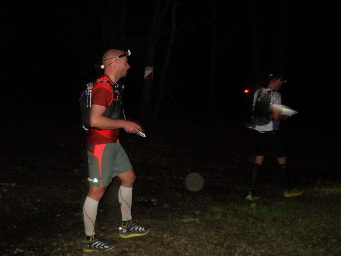
Kierat came up about a year ago when I was browsing around for races. Noted it in the back off my head as a possibility but it was when my running and travel buddy Jakob found out he wanted a Western States lottery ticket and wanted to use Kierat to get it that it ended up in my calendar.
The race has a different approach than most other races and are basicly a 100km orienteering race with 3500 meters of elevation on paper. What you end up with in terms of distance and elevation is up to you on the basis of route choice and your abilities to follow that route while racing. You are given a map with the checkpoints plotted maximum 6 hours before the start, which gives you enough time to plan and mark your route before starting. You are also allowed to use a GPS and others maps if you want. To get the Western States ticket, you have 27 hours to complete the course, but 30 hours is the official time limit.
We booked our entry as soon as the entries opened and secured a room at the Hotel Ziwy Brzeg, but there are multiple options for sleeping. The price for the entry and accommodation was low, so choosing a good bed to sleep in fitted out bill perfectly. The event website and response to our questions on email was very good, and considering how few foreigners competing, the english portion of the page are extremely good. The only thing missing was a english version of the news that where posted the days leading up to the race.
We flew down on thursday to Katowice and rented a car. Drove the short distance down to Krakow and spent the night there after a quick stroll getting a small glimpse of the city. Registration opened at 12:00 race day, so we had plenty of time driving down to Limanowa, just stopping to get some supplies on the way. Limanowa was a bigger city than I was expecting and everything you need is in walking distance from the race HQ should you need anything. Super easy with parking just outside the hotel and HQ. Within minutes we had checked in, registered and were busy scanning the map planning our route. A quick tip is to bring markers. The point of marking your route before the race is quite simply because your head will be in another state during the night 10 hours into the race and having taken the choice what route to take makes the job (a bit) easier.
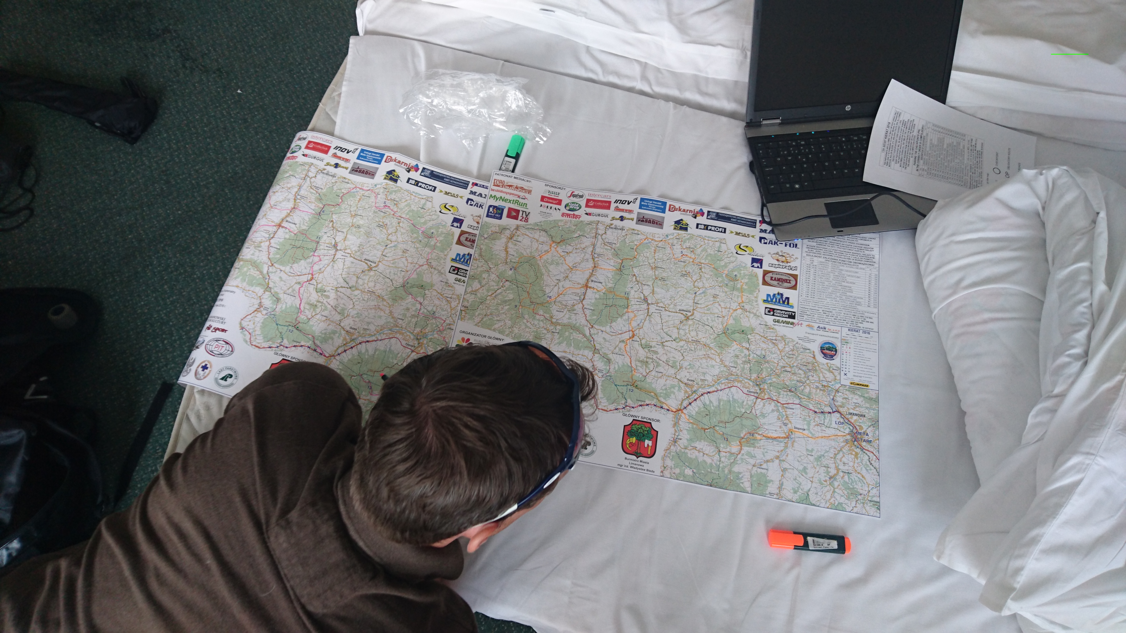
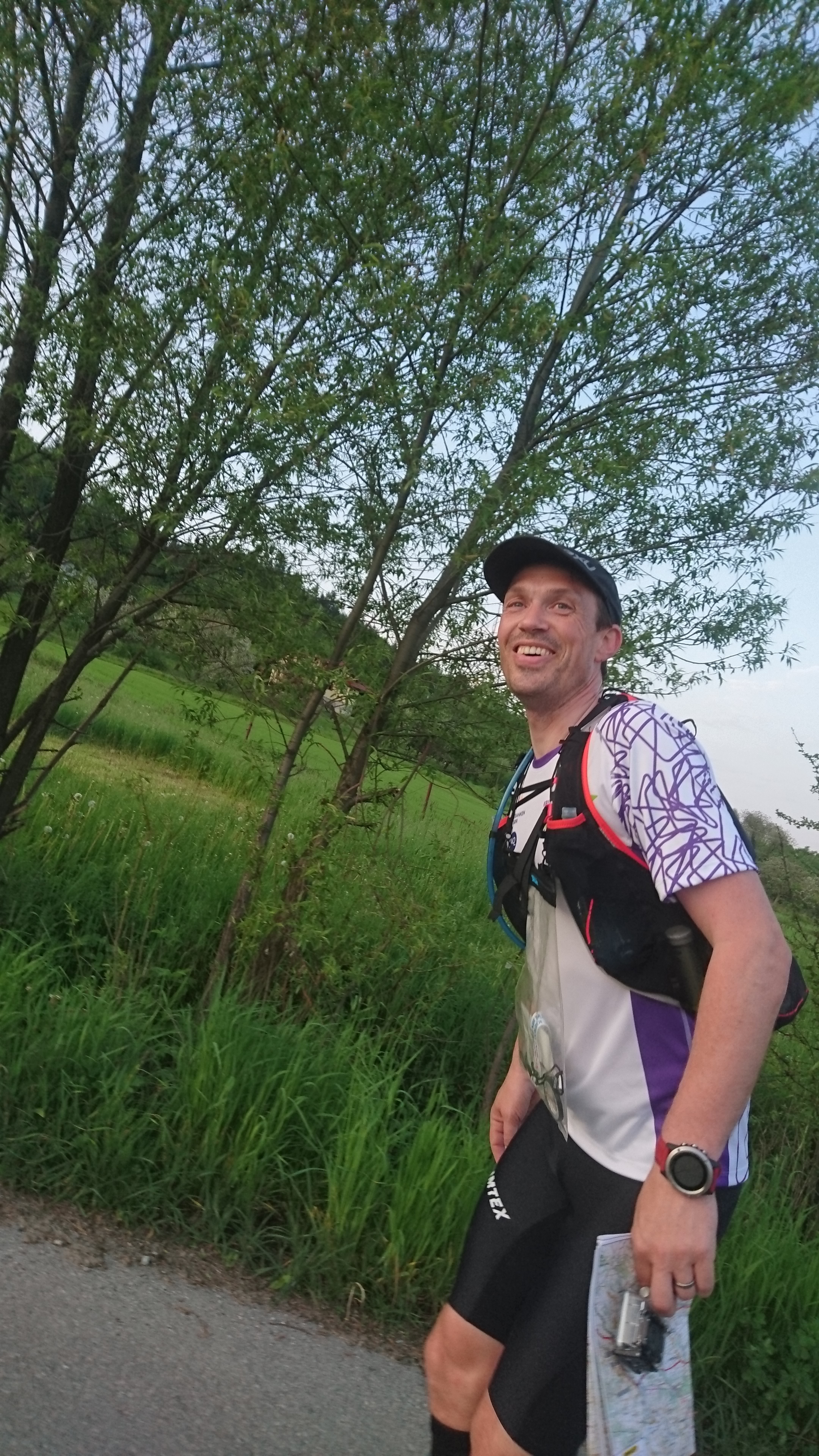
After the route was planned, we sorted our kit and headed out for our last meal before the start at 18:00. Some pizza slices and some fluids later, we found out we probably needed something better than the thin zip-lock plastic bag we were given at registration to keep our maps in. A visit to the 4-5 sports shops in town didn’t give much result, but luckily there was a stand right next to the registration who sold map cases. After that we did our last preparations and headed to the starting point in the nearby park where there would be a briefing. If you do not understand a word polish you might aswell turn up just before the start. 2 minutter before the start people lined up, and after a short wait and a countdown we headed off.
I have detailed how we navigated the whole route, but if you’re not interested and want to get to the important stuff click here to get to it.
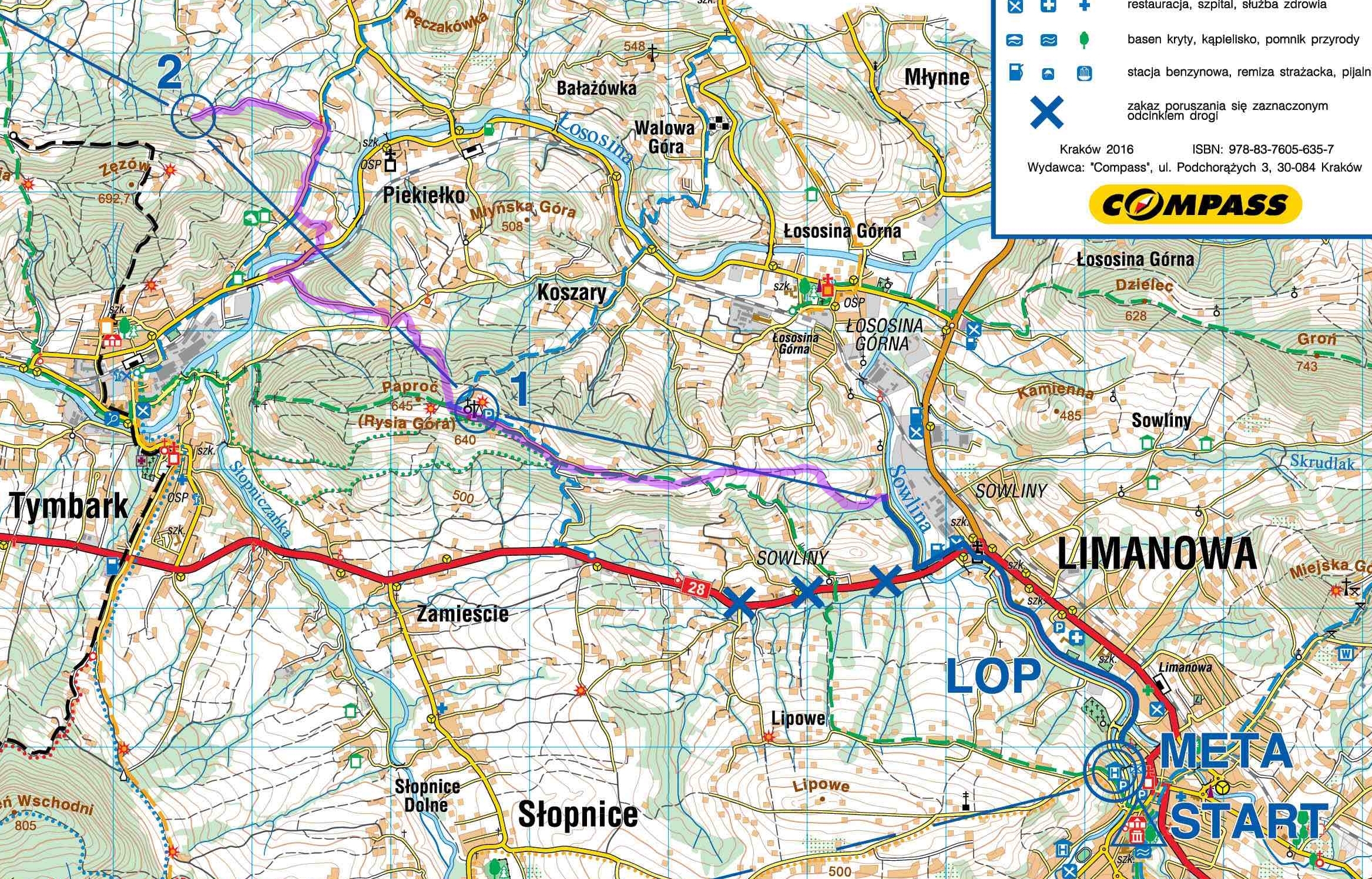
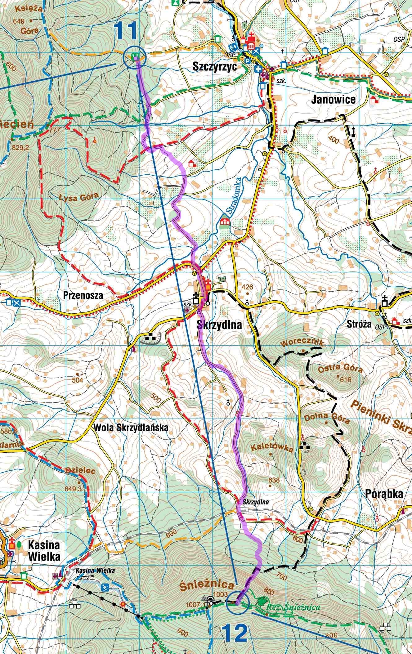
The first part from the start to the first checkpoint followed a set (and marked) route out off town. The pace was quite comfortable and we settled a bit back from the front at about 100+ place. Navigating to the first checkpoint was easy on paper, but we immediately got a little setback when a paved road emerged where the map showed a trail. We followed the pack up and along a ridge and tried to get a feel of distances on the 1:50 000 map we had available. At the checkpoint we scanned our cards at the reader and showed our race bib so the volunteers could take a manual backup on their lists.
We followed as planned towards checkpoint 2, cutting off right from the green path down to the road straight under the line between the checkpoints. Passed the railroad and turned right along a paved road over the river. Turned off a bit to early but came up to the blue path and followed that to the shrine. Turned left and followed the path to the checkpoint. So far so good.
From checkpoint 2 we followed the path straight until we hit the green path, turned right and followed it down to the paved road. Easy navigating from the fork at the end of the paved road and we followed the large gravel road straight down to the checkpoint.
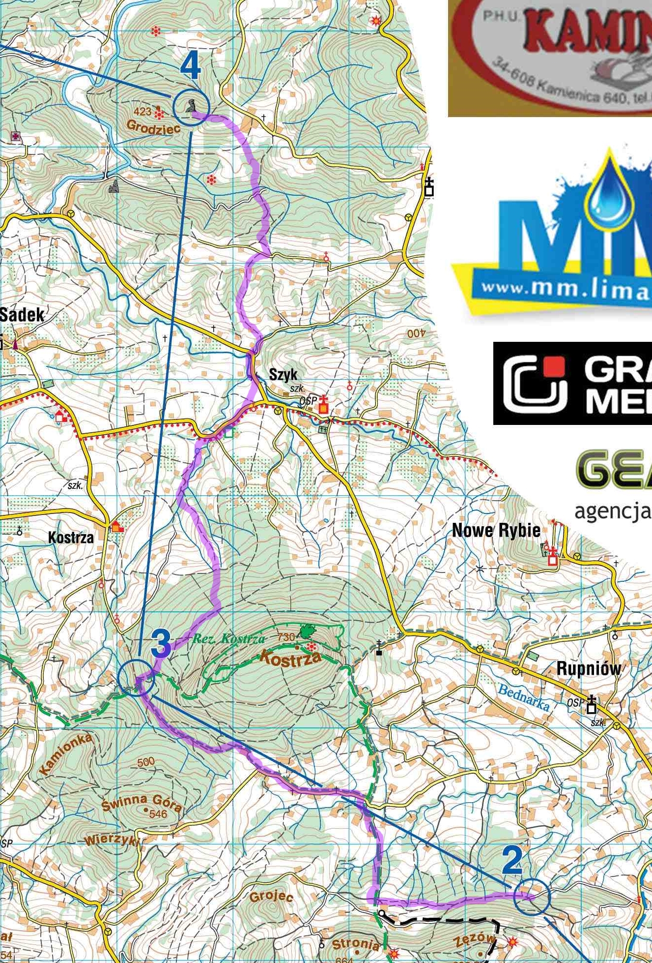
Going to checkpoint 4 our plan was to use the larger road a couple of hundred meters further down, but we ended up going right to early following the forest path. We cut left when we “felt for it” and managed to hit the paved road right about where we wanted to. After we left the paved road we planned to follow the forest paths onto the yellow road but cut instead straight towards the checkpoint. Coming up on the ridge I turned on my GPS to guide us the last hundred meters to the checkpoint. So far mostly as planned and no major mistakes. It got dark at about 21:00 and we had to get our headlamps out just before we got to the checkpoint.

We were a bit unsure about what options there where for getting over the river and getting down to it leading out from checkpoint 4, the bridge on the map was washed away. We meet a large group standing on the other bank yelling something we had no possibility to understand. Used to getting our feet wet, we jumped in and quickly got over to the other side, the water only barely getting over our ankles. We passed over a field and our bearings got a little skewed, but we latched on to a polish guy who seemed to know where he was going. As we passed the house just after the river we had to run through a field littered with stinging nettles burning our not so well covered knees. This repeated a few more times along the route and I’m so glad I opted for compression calves at least covering large part of my legs. Without them the pain would have been a lot worse. Getting up to the bigger roads we managed to get our heads around where we were and the rest of the way we followed the paved roads as planned. At the checkpoint there where water available, and we filled up and got going.
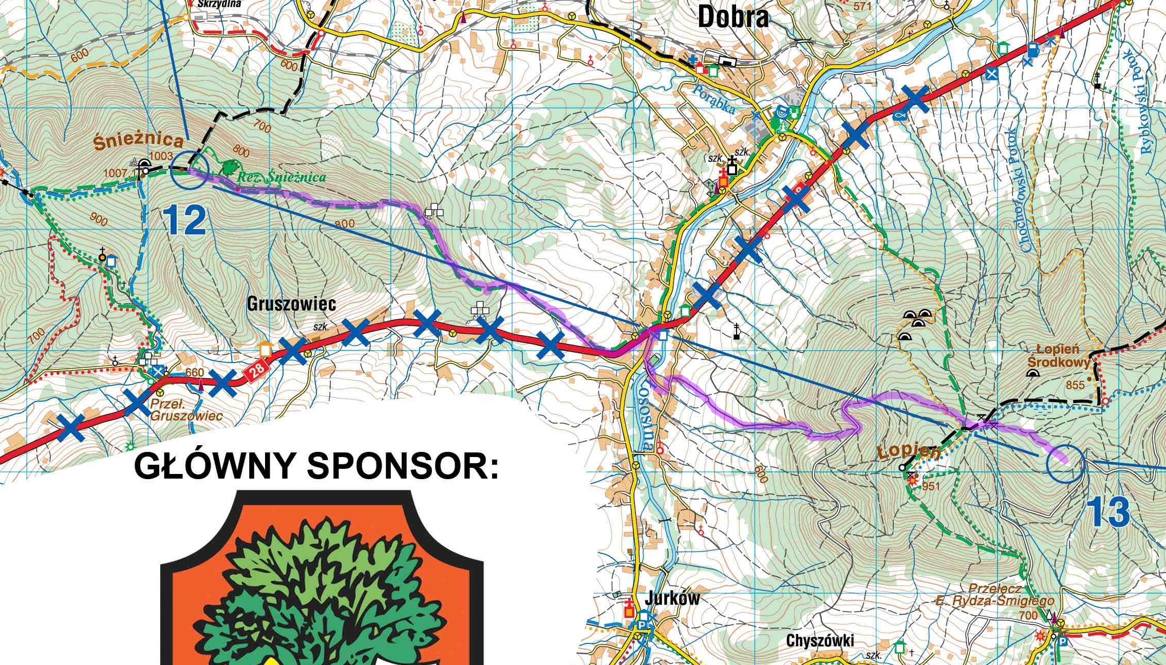
We planned going the long way north following paved roads almost to the checkpoint thinking we could have a relaxed navigation and try to eat and drink. We adjusted the plan leading into the checkpoint not following the black path but instead following the paved road a bit further and came straight up into the post slightly helped by the GPS.
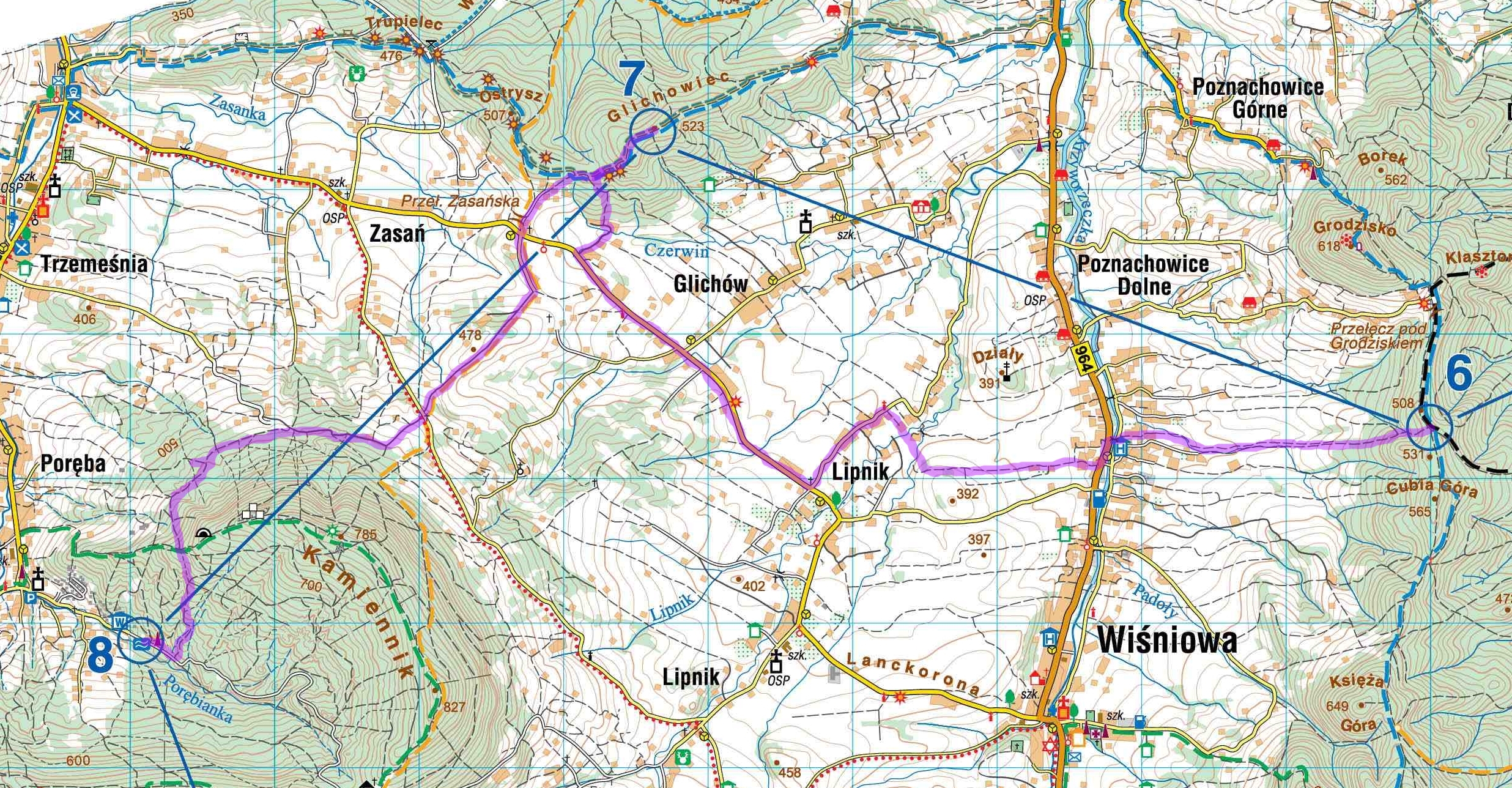
Going down from checkpoint 6 we managed to get on our planned path and hit the paved road exactly where we wanted: by the bridge. We did not follow it left as far as we wanted because we ended up having to go through some fields and crossing a creek at Lipnik. We should have adopted our plan seeing where we ended up and followed a forest path straight for the checkpoint, but followed our plan of going the long way left using the paved road. We where together with another pair at Lipnik who took the straight route who we meet going up the last hundred meters coming down from it. We probably only lost a couple of minutes.
Checkpoint 8 was halfway and hot beverages were awaiting. Easy navigation the first half, but a little more difficult at the end. The hard part being we did not want to gain or lose too much altitude. We had overtaken two other pairs of runners and where switching on the lead most of the way. Into the checkpoint the GPS once again helped a lot choosing the right path. We ended up gaining a little more than we ideally would have, but again still no major mistakes. Coming in to checkpoint there were a selection of hot beverages (coffee, tea, soup) and some sandwiches. I had two cups of tea with loads of sugar and put on my light jacket before we headed out again. By checking the backup form at the checkpoint I noticed we were 2 hours behind the leaders at this point. Not too shabby.
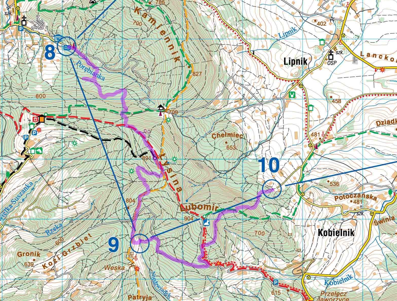
Coming out off the checkpoint I started feeling nauseated. The tea? Probably. Our plan was to follow the white path until we meet the yellow, and then follow that more or less to the checkpoint. We somehow missed the turn and ended up on a big timbertrack not on the map who we hoped would merge with our intended trail. Maybe we were tired but we lost our sense of direction a couple off times and didn’t quite interpret the contourlines correct. We ended up going straight at the checkpoint by GPS until we hit the green path and then the red path. We followed that until what we thought was the yellow path went right, but ended up on another path. We eventually felt we were going the wrong way and had to cut through straight for the yellow path again. Once on the yellow path we found the next checkpoint easily. Comparing times for this leg, it would seem we lost about 45 minutters on our stupid mistake in the beginning of the leg.
We had used a lot of time planning the next leg wanting to go around the hill instead of going over. We came in together with another pair at the checkpoint and left and ran the leg more or less together with them. Once again it felt great having navigated the leg as planned and feeling the route chosen was more or less optimal. As we came out of the forest into the checkpoint morning had arrived and headlamps could be stowed away as we walked down the road leading onwards.
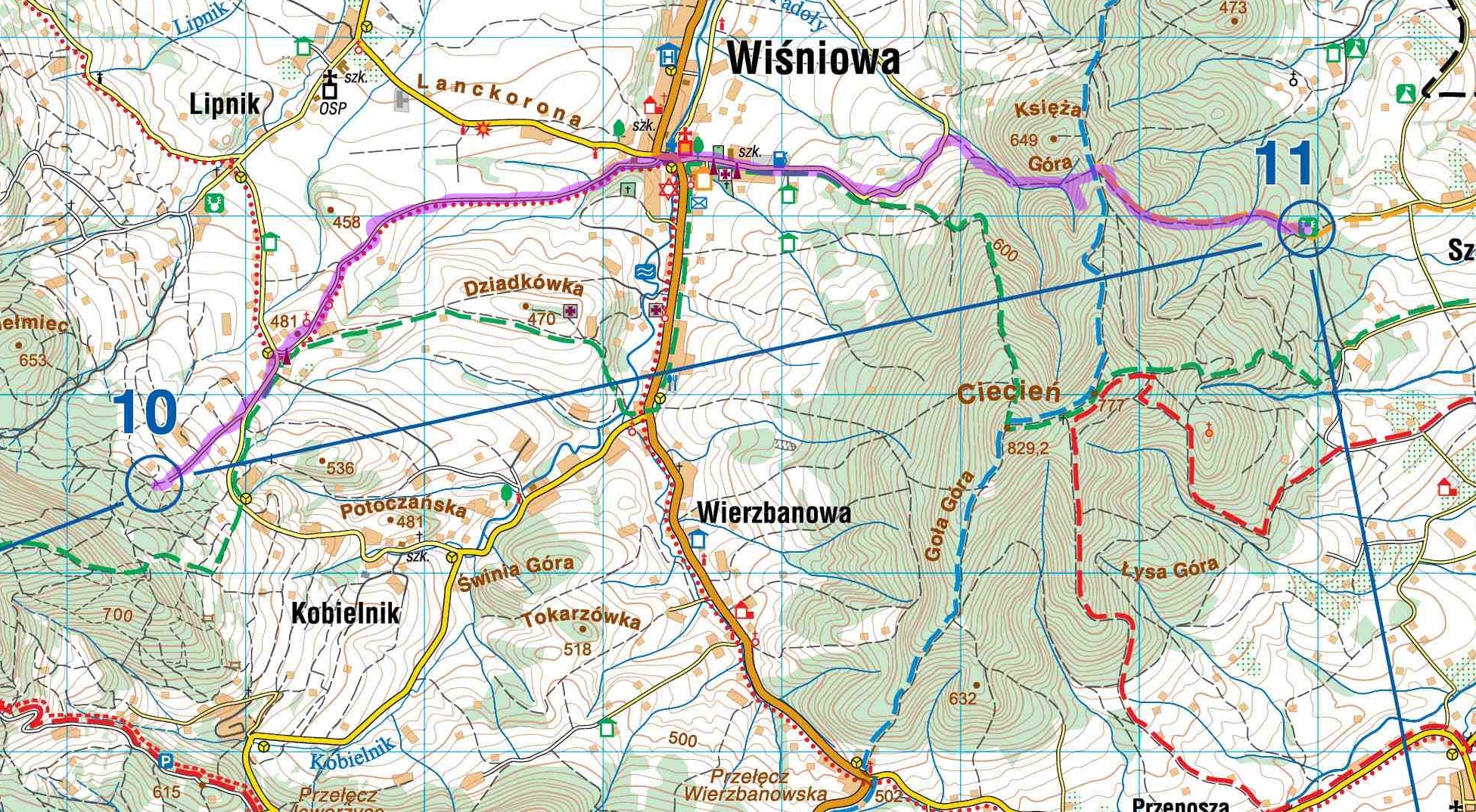
The underside of my feet started feeling very sore as we trotted and walked down the paved road. The other pair off runners left us in the dust as they ran down the hill. We had to walk a bit before we found our running legs again. Easy navigation on this leg and we followed our plan almost to the dot, just wearing off a couple of hundred meters just before we hit the blue path. We gained on the other pair on the uphills and managed to get to the checkpoint a couple of minutes before them. At the checkpoint there was a heavenly warm salty soup and white bread, which was perfect at this point in the race. We sat down and feasted before heading out again, our spirits high.
Once again a quite easy leg to navigate, but you have to be observant as it’s easy to miss or choose the wrong path somewhere. We got down to the small village and had a pitstop. Jakob had an ice cream and water, myself a coke. Coke is magic. It was slow walking at the paved road leading towards the looming hill in front of us. Jakob started to feel pain in his back and has to lie down on the tarmac for a couple of minutes before we could trott on. Missed the path that is on the map, but ended up finding the black steep path leading to the summit. Jakob’s back didn’t get any better on the steep ascent, and I went ahead to the summit and waited for him there. Took out my mobile, sent some messages, posted a status for those who were interested at home and chatted a bit with the crew at the summit. Jakob crested some minutes later and looked a bit warm and knackered. We spent some minutes adjusting his backpack as his camelback had clogged up and continued.

As we left the checkpoint I felt fresh and eager to run. Our plan was to keep together for the first bit and then see what happened. It was now day again and I felt it was time to run the rest of the race as individuals. A quick questions if that was ok and I started running down the hill following the green technical path down to the valley. It felt great having running legs, “dancing” down the hill in a what felt like a decent pace. Overtook a couple of runners coming down to the river. Made a small unintentional detour but found the planned path up the hill and started powerwalking upwards. Overtook even more runners on the way up. I was flying. Found the rights path quick and with the help of the GPS went straight into the checkpoint.
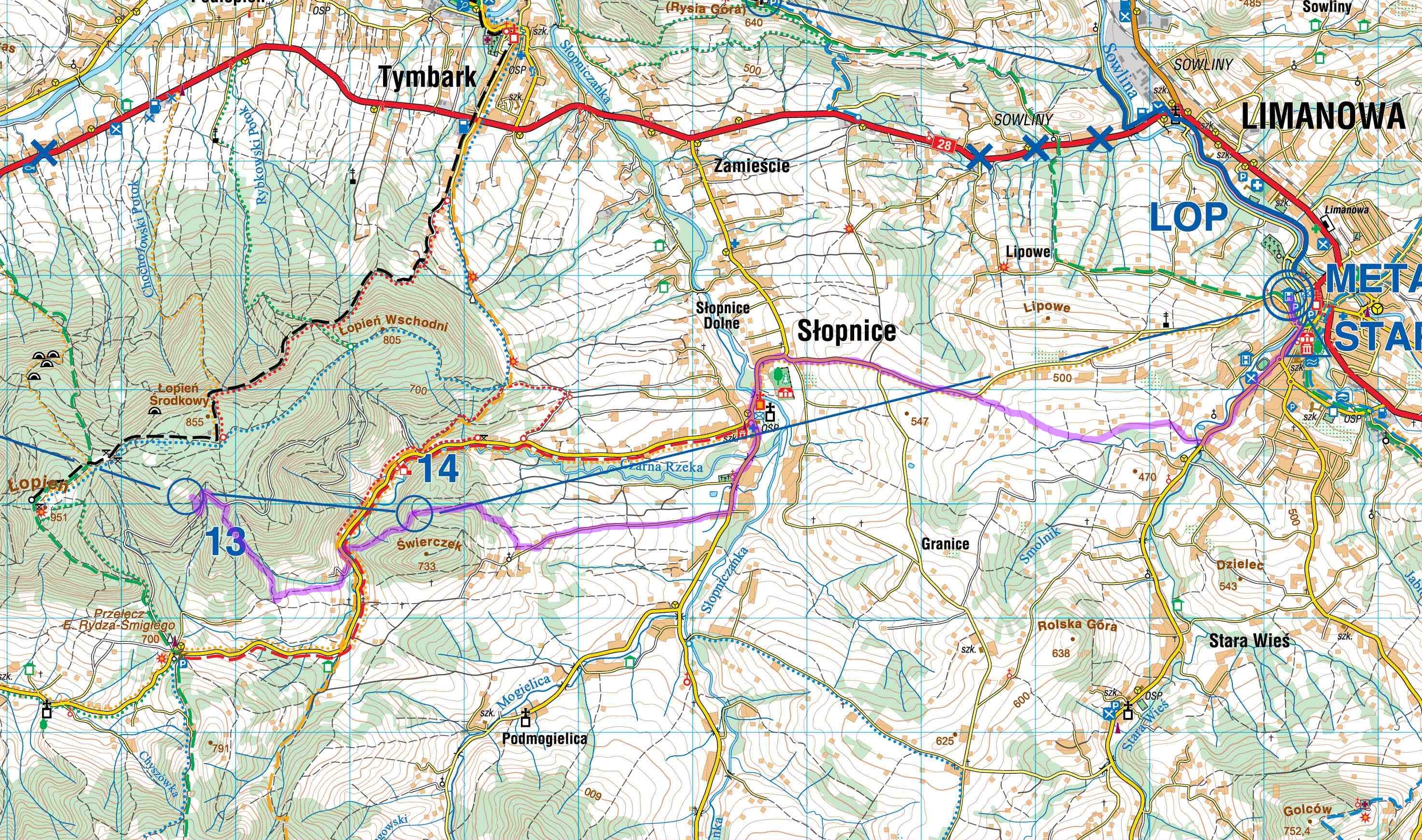
Almost on the home stretch now, but managed to loose a few minutes coming down from the checkpoint down to to the first road. Found the trail on the right leading down to the valley. The path over the meadow was non existent, but got down to the tarmac and found the crossing and path leading directly to the checkpoint. Saw quite a few runners to my left coming up the hill from the other side as I went into and registered at the checkpoint.
I was a bit quick running out as I intended to run the left path and directly down to the paved road, but ended up following the path to much to the right. Got on track and caught four runners as I went through Slopnice. As we came over the the top I started running and overtook them easily, they running only short distances before walking again. In the fork a few hundred meters further I went straight as this was the biggest road (not on the map) and started doubting it when the road didn’t turn left as it was supposed to. Gritted my teeth and just ran thinking I would hit the road leading down to town anyways. Managed to keep running strong all the way to the finish thinking about the four runners taking the other shorter route and maybe beating me talking the shorter more direct route.
I finished in 17:36 in 23th position moderately happy with my time. I had 16:00 as my target but losing a lot on a few legs and being a bit held up running with Jakob in the middle part the result was decent. I would have taken a lot less in my vest, not eating half what I had brought with me. I do recommend bringing a GPS as it helps enormously the last kilometer going into a checkpoint. I ran in my Hoka One One Speedgoats and that was perfect in the mixed surfaces we faced. We both had poles which for me relieves the legs both going up and down. Half the field seemed to use them. Use a lot of time to plan your route and mark it well. Bring a marker and a map pocket. Cover your legs so you don’t get burned and to protect your calves from the undergrowth. A fun and well organized event which I can recommend. The entry fee is basically only two pints worth in Norway so that won’t clean out you wallet either.
I ended up with a total of 107 kilometers and about 4100 meters of elevation.
As far as the difficulty of getting under the 27-hour limit for the Western States ticket it seems to me to be quite manageable for most people as long as you know basic navigation.
Leave a Reply